Tropical Storm Ernesto, Atlantic hurricane season, Ernesto path, hurricane forecast, Caribbean storm, Bermuda High, storm tracking, 2024 Atlantic hurricane season, hurricane preparedness, Gulf Coast weather
Explore the formation and potential impact of Tropical Storm Ernesto as it moves through the Atlantic. This article provides detailed insights into Ernesto’s expected path, the environmental factors influencing its trajectory, and the current forecasts predicting its possible intensification into a hurricane. Stay informed on the latest developments in the 2024 Atlantic hurricane season.
Tropical Storm Ernesto Forms in the Atlantic: Tracking the Path and Potential Impact
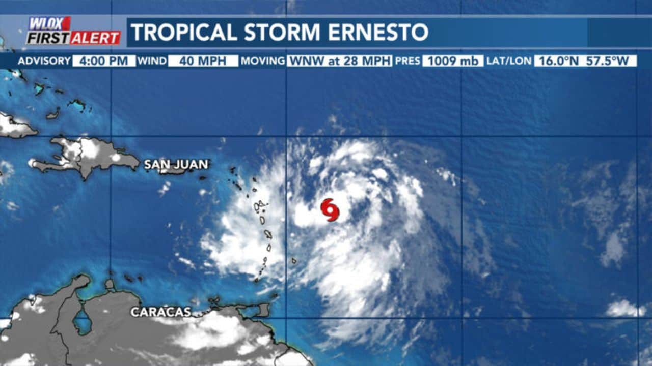
As of Monday afternoon, Tropical Storm Ernesto has officially formed in the Atlantic Ocean, just east of the Lesser Antilles. This development marks the latest in the 2024 hurricane season, as tropical activity ramps up in the Atlantic basin. Meteorologists and weather enthusiasts alike are now closely monitoring Ernesto’s trajectory and potential impact as it moves towards the Caribbean and possibly beyond.
Formation and Current Status of Tropical Storm Ernesto
Tropical Storm Ernesto was first detected as a tropical disturbance in the eastern Atlantic. Over the course of several days, it gradually organized and gained strength, eventually reaching tropical storm status on Monday. The storm is currently situated just east of the Lesser Antilles, a chain of islands that form the eastern boundary of the Caribbean Sea.
The WLOX First Alert Weather Team, along with other meteorological organizations, will continue to track Ernesto as it progresses westward into the Caribbean. According to current forecasts, Ernesto is expected to strengthen as it encounters favorable environmental conditions in the coming days.
Forecast and Strengthening of Ernesto
Forecast models from the National Hurricane Center (NHC) are in agreement that Ernesto will continue to intensify as it moves towards the Lesser Antilles and Puerto Rico. The storm is currently traversing an area with warm sea surface temperatures and low wind shear—both of which are conducive to tropical cyclone development and strengthening.
The NHC’s forecast indicates that Ernesto could reach hurricane strength by the end of the week. If this projection holds true, Ernesto would become the first hurricane of the 2024 Atlantic hurricane season, setting the stage for potentially significant impacts in the Caribbean and possibly further afield.
Potential Track and Impact on the Mainland U.S. and Gulf Coast
While Ernesto is expected to strengthen in the coming days, the level of concern for South Mississippi and the Gulf Coast remains low at this time. Forecast models have been fairly consistent in showing Ernesto taking a path that would steer it away from the mainland United States and the Gulf Coast. However, it is important to note that long-range forecasts—those that extend five to seven days into the future—do come with a degree of uncertainty.
Most models currently predict that Ernesto will continue its westward journey into the Caribbean before making a turn to the north and re-entering the Atlantic Ocean. This northward turn is expected to occur by midweek, which would effectively keep Ernesto away from the U.S. mainland. The key factor in this forecast is the presence of a high-pressure system known as the Bermuda High, which plays a crucial role in steering tropical cyclones in the Atlantic.
The Influence of the Bermuda High and Other Environmental Factors
The track of Tropical Storm Ernesto is heavily influenced by the strength and positioning of the Bermuda High—a semi-permanent area of high pressure over the central Atlantic. In this particular scenario, a trough of low pressure is expected to dig in from the north, weakening the Bermuda High and allowing Ernesto to turn northward. This anticipated turn would likely spare the mainland U.S. and Gulf Coast from any direct impact.
In addition to the Bermuda High, other environmental conditions will play a role in Ernesto’s development. As the storm moves into the Caribbean and then back into the Atlantic, it will encounter warm ocean waters and favorable atmospheric conditions, including low wind shear. These factors are expected to facilitate further strengthening, with some models even suggesting that Ernesto could become a major hurricane by the end of the week.
Long-Range Forecasts and Uncertainties
While the current forecast models suggest that Ernesto will turn northward and avoid the U.S. mainland, it is important to remember that tropical cyclones are inherently unpredictable. Even slight changes in the strength or position of the Bermuda High, or other atmospheric conditions, could alter Ernesto’s path. As such, residents along the Gulf Coast and the eastern seaboard should continue to monitor the storm’s progress over the coming days.
Long-range forecasts, which look several days into the future, often come with a degree of uncertainty. Meteorologists use a variety of models and tools to predict the behavior of tropical storms, but the dynamic nature of the atmosphere means that small changes can have significant impacts on a storm’s track and intensity. For this reason, it is essential to stay informed and be prepared for any potential changes in the forecast.
The 2024 Atlantic Hurricane Season and the Importance of Preparedness
The formation of Tropical Storm Ernesto comes as no surprise, given that the peak of the Atlantic hurricane season typically occurs in August and September. According to data from Colorado State University, nearly 85% of all tropical systems in the Atlantic form after August 15. This period is characterized by warm sea surface temperatures and favorable atmospheric conditions that can give rise to powerful hurricanes.
As Ernesto continues to develop, it serves as a reminder of the importance of hurricane preparedness. Even though the current forecast suggests that Ernesto will not pose a significant threat to the mainland U.S., it is still vital for residents in hurricane-prone areas to have a plan in place. This includes knowing evacuation routes, securing property, and having a supply of essential items such as food, water, and medications.
Historical Context and the Naming of Tropical Systems
The 2024 Atlantic hurricane season has already seen several named storms, and Ernesto is the latest addition to the list. The naming of tropical storms and hurricanes follows a predetermined list set by the World Meteorological Organization (WMO). The names are selected to be easily recognizable and are rotated every six years. If a storm is particularly destructive, its name is retired and replaced with a new one.
After Ernesto, the next names on the list for the 2024 season are Francine and Gordon. While it is impossible to predict how many more storms will form this season, the arrival of Ernesto underscores the need for continued vigilance as the peak of hurricane activity approaches.
Conclusion: Monitoring Ernesto and Staying Informed
As Tropical Storm Ernesto continues to move westward, meteorologists and residents alike will be closely monitoring its progress. While the current forecast suggests that Ernesto will strengthen into a hurricane and eventually turn northward into the Atlantic, there is still a level of uncertainty regarding its exact path and intensity.
For now, the concern for the mainland U.S. and Gulf Coast remains low, but it is essential to stay informed and be prepared for any changes in the forecast. The 2024 hurricane season is far from over, and Ernesto may be just one of several storms that will require attention in the coming weeks.
As always, the WLOX First Alert Weather Team will provide the latest updates and information on Ernesto and other tropical systems. By staying informed and prepared, residents can ensure their safety and well-being throughout the hurricane season.
Read More